Continent and Life Evolution
ISSN: 3008-0851 (Print)
ISSN: 3008-086X (Online)
CODEN: CLEABK
Late Cenomanian radiolitid rudists from the Jingzhushan Formation of the northern Lhasa Terrane
This study documents a late Cenomanian (Late Cretaceous) radiolitid rudist assemblage from the basal part of the Jingzhushan Formation in the northern Lhasa Terrane, Qinghai-Tibetan Plateau. The radiolitid fauna includes Paronaites zuffardii, Eoradiolites liratus, Sauvagesia cf. sharpei, and Auroradiolites biconvexus, with the first three species constituting a characteristic late Cenomanian association widely distributed in the Mediterranean Tethys and the Middle East. Their presence in the Jingzhushan Formation, previously interpreted as deposited in alluvial-fan and braided-river systems, provides definitive evidence for a shallow-marine carbonate platform environment in the northern Lhasa Terrane during the late Cenomanian. The co-occurrence of the primitive genus Auroradiolites with more advanced radiolitids suggests a significant faunal transition and a notable radiation event of the Family Radiolitidae in eastern Tethys during the early Late Cretaceous. These findings contribute to understanding the paleogeographic evolution of the eastern Tethys, and the stratigraphic correlation of Cenomanian shallow-water carbonates between the eastern and western Tethys.

Obliquity-modulated poleward rain-belt shifts recorded in the Pliocene-Pleistocene sequence, northern Chinese Loess Plateau
Earth’s axial tilt modulates meridional insolation gradients and, in turn, the latitude of the tropical rainbelt/Intertropical Convergence Zone (ITCZ). We test this mechanism at the northern limit of the Asian summer monsoon using a 63.5-m red clay–loess succession on the northern Chinese Loess Plateau (CLP). New magnetic susceptibility (χ) and grain-size (< 5 μm) series, anchored by magnetostratigraphy and refined by astronomical tuning, reveal statistically significant 405 kyr eccentricity, ~173 kyr obliquity modulation, and ~1.2 Myr bands. We iteratively tuned the χ series to the astronomical solution using the ~173 kyr obliquity-modulation filter, and independently validated the chronology against the 405 kyr eccentricity band; evolutive spectral analysis further verifies the cyclic pacing and phase relationships. Band-pass reconstructions show that χ maxima broadly coincide with obliquity amplitude highs, consistent with strengthened summer monsoon and northward rainbelt displacement. Coherence with χ from nearby CLP sections (Wujiamao, Lingtai) and with benthic δ18O–δ13C further supports regional to global controls. We interpret the CLP record as an obliquity-gated archive of ITCZ poleward pulses during the Pliocene-Pleistocene, modulated by 173 kyr (Earth-Saturn) and ~1.2 Myr (Earth-Mars) beats, superposed on the long-eccentricity metronome. The tuned framework provides a physically grounded chronology for future multi-proxy work and a benchmark for testing monsoon-ITCZ dynamics in warm-climate simulations.

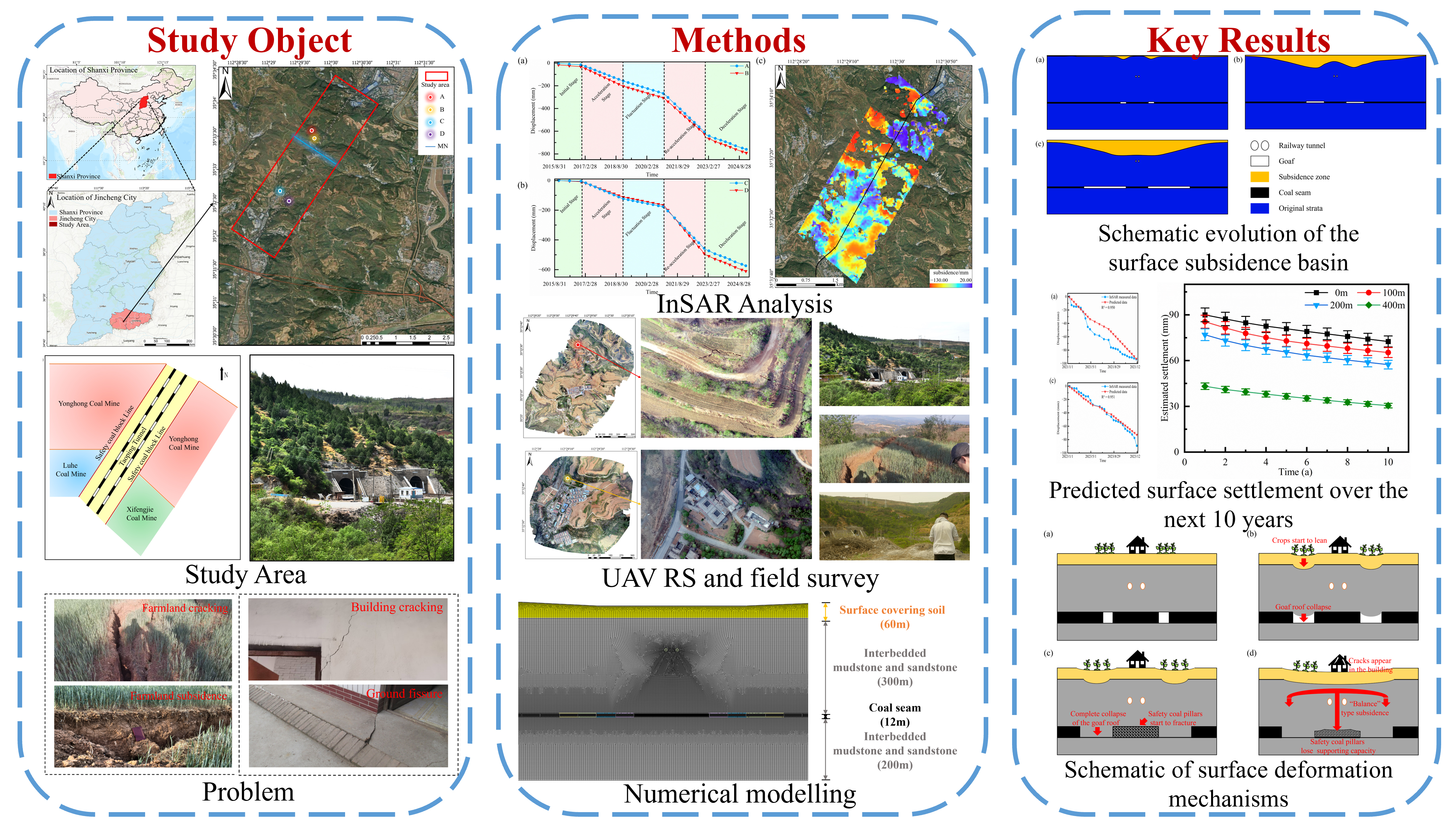
Surface subsidence patterns and mechanisms of underlying goaf beneath a railway tunnel
Long-term deformation of abandoned mine workings endangers surface infrastructure, causing wall cracking, beam–column distortion and, in extreme cases, tilting or collapse. Here we track surface movement above the Taoping tunnel goaf beneath the Houyue railway (Shanxi, China) by combining 2015–2024 InSAR time-series, numerical modelling and probability-integral analysis. Contrary to widely held stability assumptions, subsidence is still accelerating more than a decade after extraction ceased. Five evolutionary stages are identified: (1) initial roof failure and local basin formation; (2) stress redistribution that loads the safety coal pillar; (3) progressive pillar crushing; (4) merger of adjacent goafs into a “balanced” instability structure; and (5) transformation of the local basin into a regional trough. Probability-integral forecasting indicates residual settlement will continue for roughly ten years before stabilization. The proposed stage-based framework enables long-term stability assessment and targeted remediation of similar legacy goafs, and supports safe railway operation and future land reuse.
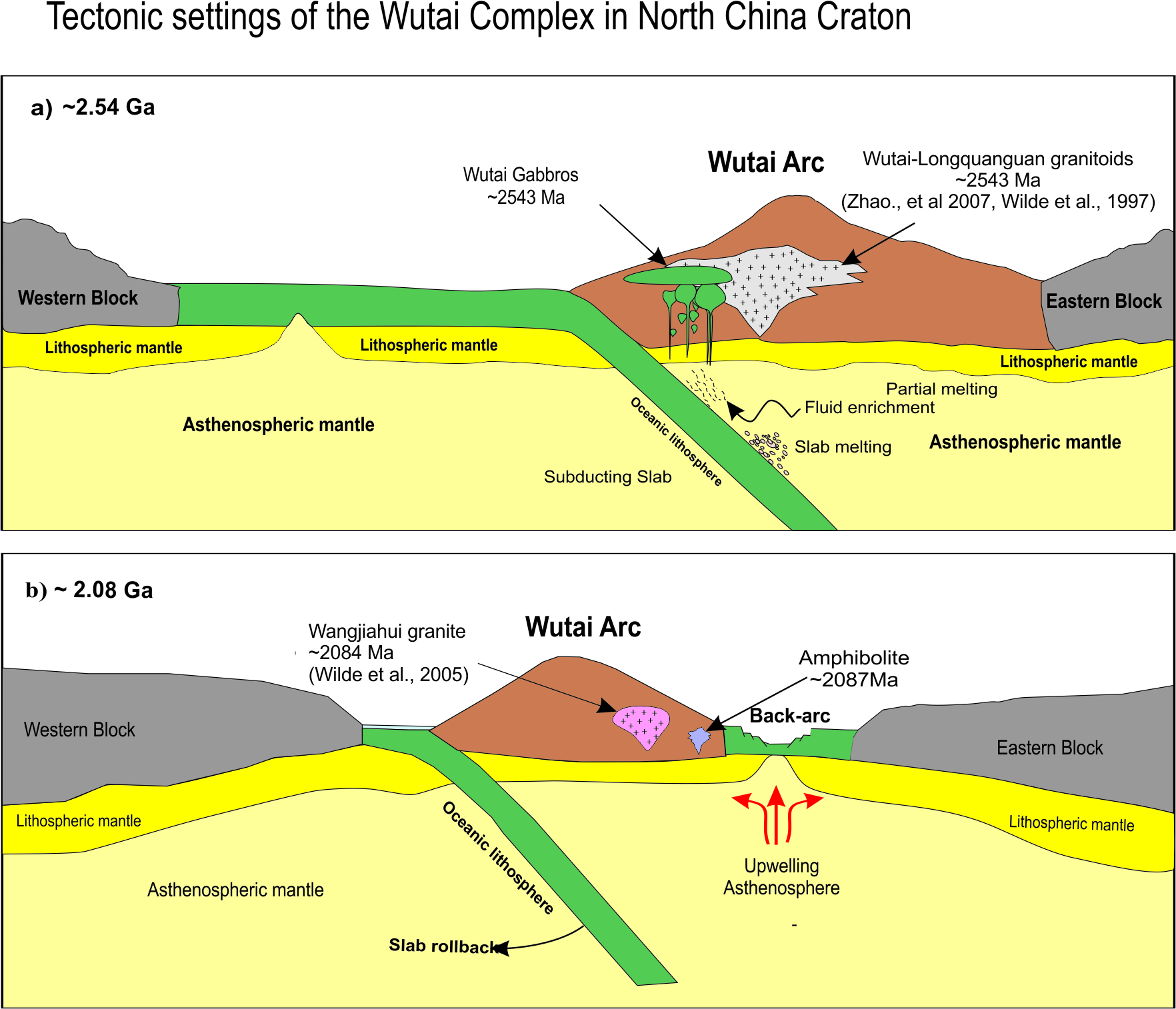
Geochronology and geochemistry of mafic rocks in the Wutai area, North China: constraints on the latest Neoarchean–Paleoproterozoic tectonic setting of the Trans-North China Orogen and the onset of plate tectonics
The Neoarchean-Paleoproterozoic is a key period for the North China Craton due to the formation of continental crust and the beginning of oceanic subduction. The amalgamation of the Eastern and Western blocks of the North China Craton remains debated, particularly regarding the timing, directionality (eastward vs. westward subduction), and number of collisional phases. Previous studies disproportionately focus on felsic lithologies, creating a critical mafic blind spot that obscures insights into mantle dynamics and crust-mantle interactions. Systematic investigation of Late Archean to Paleoproterozoic mafic suites was essential to reconcile conflicting tectonic models and refine the craton’s amalgamation history. In order to constrain the complex geological processes more clearly, we present new whole-rock geochemistry and zircon U-Pb geochronology for mafic rocks in the Wutai Complex. The Late Archean (2.56~2.54 Ga) gabbros are characterized by relatively depleted Nb–Ta and Zr–Hf anomalies, slightly positive Eu* anomalies, low K₂O concentrations, enrichments of LILE (Ba, CS, Th, and Rb), differentiated HFSE patterns and moderate Mg# values (43–53). They show positive εNd (t) values (+4.9–+6.1) and high (⁸⁷Sr/⁸⁶Sr)i ratios (0.70063–0.70091). Additionally, these gabbros have high Nb concentration (13.3–23.3) and display enrichments in light rare earth elements (LREE) (La/Yb)N = 7.00–8.96), high-field strength elements (HFSE, e.g., Nb, Ta, Zr), and high Nb/U and Nb/La ratios, suggesting a derivation from an arc-like mantle source. The gabbro melts were generated by a low degree of 4%–5% partial melting of garnet-spinel lherzolite mantle. The Paleoproterozoic (2.16~2.08 Ga) amphibolites also display depleted Nb-Ta and Zr-Hf anomalies, enriched light rare earth elements (LREEs), but show lower Eu* anomalies, εNd(t) values (+0.9–+1.2), and (⁸⁷Sr/⁸⁶Sr)i ratios (0.69770–0.69930). The amphibolites exhibit a geochemical signature marked by LREE enrichment, negative HFSE anomalies, and distinct Sm-Nd isotopic composition, suggesting a subduction-related magma source. The enrichment of Cs, Rb, Ba, and the depletion of Nb, Ta, P, and Ti, imply that their magma source was significantly modified by subducted crustal materials. The trace element ratios, such as K/Rb, Rb/Y, Nb/Y, Th/Zr, and so on, further indicate that the gabbros were derived from a mantle substantially altered by siliceous slab-derived melts, whereas the amphibolites originated from a mantle influenced by slab-derived melts and fluids. The amphibolites were generated by the 15% partial melting of garnet-spinel lherzolite and the 15% melting of spinel lherzolite at a shallower mantle source. In combination with the previously published data of mafic rocks in the Wutai Complex, we infer that the Late Archean gabbros suggest their derivation in a subduction-related setting, whereas the Paleoproterozoic amphibolites formed in a back-arc basin setting. These findings underscore a tectonic transition from Late Archean oceanic subduction to Paleoproterozoic lithospheric extension in the North China Craton, indicating that plate tectonics at least partly happened most likely in the latest Neoarchean.
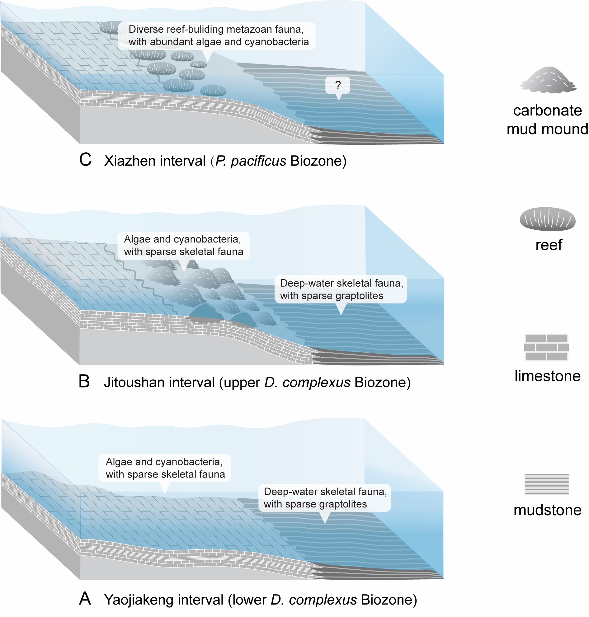
Stratigraphic refinement unveils high-resolution shallow marine biotic dynamics immediately preceding the Late Ordovician Mass Extinction in South China
Exceptionally preserved Late Ordovician successions in South China offer a globally significant archive for investigating both the Great Ordovician Biodiversification Event (GOBE) and the Late Ordovician Mass Extinction (LOME). In contrast to the graptolitic facies that dominate much of the region, the late Katian carbonate deposits in the Jiangshan–Changshan–Yushan (JCY) area of East China (South China paleoplate), formerly referred to as the Sanqushan Formation (or its equivalents), are virtually the only strata in South China preserving diverse shallow marine biotas, providing rare ecological snapshots of the final biodiversity peak of the GOBE immediately preceding the LOME. Despite their importance, the lithostratigraphic framework and age constraints of these fossiliferous rocks remain debated. The prevailing view interprets the Xiazhen Formation as a nearshore equivalent of the Sanqushan Formation, with both units broadly assigned to a generalized late Katian age. Based on a critical review of integrated sedimentologic and paleontologic data, supplemented by new field observations, we support the interpretation that the Xiazhen Formation represents the upper portion of the ‘Sanqushan Formation’, and propose to elevate the latter to group rank to represent platform facies of this entire interval. The revised Sanqushan Group comprises, in ascending order, the Yaojiakeng, the Jitoushan, and the Xiazhen formations. The Yaojiakeng and the Jitoushan formations correlate more precisely with the Dicellograptus complexus Biozone, while the Xiazhen Formation aligns with the Paraorthograptus pacificus Biozone. This refined stratigraphic framework enables high-resolution reconstruction of biotic evolution prior to the LOME, offering new insights into regional ecological dynamics and their broader global significance.
Surface subsidence patterns and mechanisms of underlying goaf beneath a railway tunnel
Long-term deformation of abandoned mine workings endangers surface infrastructure, causing wall cracking, beam–column distortion and, in extreme cases, tilting or collapse. Here we track surface movement above the Taoping tunnel goaf beneath the Houyue railway (Shanxi, China) by combining 2015–2024 InSAR time-series, numerical modelling and probability-integral analysis. Contrary to widely held stability assumptions, subsidence is still accelerating more than a decade after extraction ceased. Five evolutionary stages are identified: (1) initial roof failure and local basin formation; (2) stress redistribution that loads the safety coal pillar; (3) progressive pillar crushing; (4) merger of adjacent goafs into a “balanced” instability structure; and (5) transformation of the local basin into a regional trough. Probability-integral forecasting indicates residual settlement will continue for roughly ten years before stabilization. The proposed stage-based framework enables long-term stability assessment and targeted remediation of similar legacy goafs, and supports safe railway operation and future land reuse.